March 2026
M T W T F S S
 1
2345678
9101112131415
16171819202122
23242526272829
3031  

To the Top of Thomspon Peak

On an extraordinary fall day, I had the fortune to attempt to summit Thompson Peak (10,751) – the highest in the Sawtooth range of Idaho.  As I always say, better to be lucky than good.  An on this day I was one lucky son-of-a-gun.

Accompanying me would be my son Kyle.  A goal for the two of us this season is to summit the highest peaks in each of the five mountain ranges (Pioneer, Smoky, Boulder, Sawtooth, White Cloud) that coalesce near my home in The Wood River Valley of Idaho.  If we can make it to the top of Thompson Peak, the count would be three down; Hyndman (12,009) of the Pioneer’s, Ryan (11,714) of the Boulders and Thompson.  It would leave Castle Peak (11,813) of the White Cloud’s and Saviers of the Smoky’s as the remaining peaks to summit this year.

The biggest blocking event to achieving the goal has been forest fire.  Four major fires in the region broke out the week we topped Lubeck Peak in the Boulder Mountains (10,480).  For almost seven straight weeks the valley and region were filled with smoke and extremely unhealthy air – with the current total at approximately 890,000 acres burned (an area about the size of the State of Delaware).  We did receive breaks in the weather (i.e., wind) and summit-ed Ryan and Hyndman Peak.  Recent rain has dampened and slowed the fires – three of the four remain remain to be contained.

Thompson Peak has four approaches.  The most straight-forward approach to the summit is via the south couloir (class 3), starting from the Redfish Lake trail-head.  This approach is 6.43 miles one-way; 4,222 net vertical feet of gain (5,289 ascent and 1,157 descent).  Most people hike the first four miles of the route to the meadow at 8,000 ft or the lake at 9,000 feet and camp with a summit the next day.  Others will ascend and descend the entire route in one shot.  Kyle and I decide the one-shot approach it will be – as it has served us well to-date. However, on this day, not only would reaching the summit be a treat, the color display on the route was at times breath taking.  Kyle set a great pace on a route that included a long stretch of wonderful single-track trail, boulder hopping, snowfield traversing, an unintended free climb, rock scrambling and tidbit of glissading. We reached the summit in four hours and 21 minutes (3:47 if time for photos is removed).  Kyle signed the log book at the summit. Reading the story’s in the log book are always a treat and sometimes include a sad note.  There were some of both in this book.  One note was from a person who made the summit on there third attempt.  Another was a note of remembrance for a friend who reached the summit, signed the log, but never made it home – dieing on the descent.

After a spot of lunch and taking some more photos we headed back down to the trail-head and on to home.

The lake at 9,000 feet. Thompson Peak on the right.


Looking south from the summit of Thompson Peak. The Sawtooth Mountain Range has 41 peaks of 10,000 in elevation. Seeing Thompson Peak is at the north end, most of the others are in the shot.


The view east from the summit of Thompson Peak – The White Cloud Mountain Range, Sawtooth Valley, Little Redfish Lake, Redfish Lake and the Bench Lakes.


Our goal (Thompson Peak right center) comes into view about one-half a mile into the hike.


One mile into the hike just below the junction of the Alpine Way Trail and trail to Marshall Lake.


The wall to the ridge-line from the lake at 9,500 feet. What seemed like an easy route to the ridge-line turned into 200 vertical of class 4+ free-climbing.


The lake at 9,000 feet from the summit of Thompson Peak 1,751 feet above.


Kyle at the base of the South Couloir after summiting Thomspon Peak.

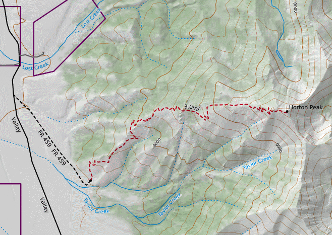
The route taken to Thompson Peak.

Color’s Hitting Their Prime

Are the fall colors in your area starting to reach their peak? Yeah I know… you really have not had a chance to get outside and enjoy because you are buried at work (or some other similar reason).  Well, the colors are about to go away soon and all you are going to have to show for it are the physical signs from a little more stress and a few extra pounds.

So do me and yourself a favor; put the budget numbers down, or the contract negotiations aside, or let the family fend for itself, or miss one episode of XYZ show, and take a few minutes or an hour or better yet a couple of hours and soak in the fall-time.  I feel safe in saying that you will actually perform better at the task(s) you think are keeping you from taking a brake in the first place.

And I am not speaking to everyone else on this mailing list – I am talkin to you!

The view of the Boulder Mountains (Silver Peak 11,112 feet) right after work.


Looking back into the Wood River Valley (and the spot from which the photo displayed above was taken) at the top of the ridge-line just below Silver Peak

Larry Lloyd at 9,648 feet elevation just below the ridge line of Silver Peak. Larry wants everyone to know the actual trail is just 48 inches below.

And then there is the ole’ picture off the car window


The views on the drive home are pretty nice too.


Return to Horton Peak

On this day I am much like the Swallow returning to Capistrano.  Only in my case it is to Horton Peak during the colors of fall.  I try to reach the top of Horton Peak at least once each year.  At 9,900 feet in height, Horton Peak sits at the southwest corner of the White Cloud Mountain Range in Idaho just across the Sawtooth Valley from Smiley Creek Lodge.  The hike to the top is 2,780 vertical feet in 2.7 miles from the trailhead. Although 1,000 of gain per mile is relatively steep, the trail-bed is single-track and in superb condition. With each foot gained in the ascent, Alturas, Perkins, Pettit and Yellow Belly lakes are revealed on the other side of the valley,  At times the lakes, combined with the view of the Sawtooth Range and its 41 peaks above 10,000 feet is nothing short of breath taking.

From the Horton Peak trail; Alturas, Perkins, Pettit and Yellow Belly lakes on September 16th, 2010

Although reaching the summit and taking in the fire lookout and The White Cloud Mountain Range is really cool and will be achieved, my real goal is to return to the spot I call the Golden Path.  The Golden path is a section of Aspen trees between 8,600 and 8,800 feet on the trail.  Each year I try to hike up and run on the trail back at the time of their peek golden color.

The Golden Path on the trail for Horton Peak Lookout on September 22nd 2012.

 My son Kyle decides to join me.  The trek is more of a surgical strike as we decide to make the hike after completing a few chores and dropping off the dogs for a Spa Day that includes nail trimming and a bath.  Linda is working the Blaine County Health fair.  We make it to the trailhead and leave at 12:30 PM.  Kyle suggests we set a double-time hiking pace, so we can take pictures casually.  We take pictures at all the spots I want and reach the summit a little after 2PM.  We figure the hiking of the 2,700+ vertical and 2.75 miles was accomplished between an hour and a hour and 15 minutes.  After a spot of water, more pictures and the completion of some human administrative tasks we depart at 2:30 PM.

On the trip up Kyle had mentioned how impressive our friend Dave Pruder’s basement/museum was on our recent trip to East Lansing MI.  Pruder has completed 79 marathons and is one of the first people to have completed one in each and every state in the US.  Pruder has a wall with a medal and time posting for each completed race. With Dave’s accomplishments in mind Kyle and I decide to do one of the things we enjoy together; running in the back-country in the mountains.

Although the route is tricky for running, we drop from almost two miles in the sky back to the Jeep in a little over 20 minutes.  We trade odd running with the camera gear backpack.  Kyle says that running through the Golden Path section is one of the most enjoyable things he has done in life and the pictures are awesome. However, they do not compare to the feeling of experiencing it first hand.

Kyle at the Trail-head of the Horton Peak Trail.

Kyle at the Summit of the Horton Peak Trail.  Castle Peak in the background.

Horton

Map of hiking route to Horton Peak